IMAGES TAKEN NEAR TO
Brodick, ISLE OF ARRAN, KA27 8AG
Introduction
This page details the photographs taken nearby to KA27 8AG by members of the Geograph project.
The Geograph project started in 2005 with the aim of publishing, organising and preserving representative images for every square kilometre of Great Britain, Ireland and the Isle of Man.

There are currently over 7.5m images from over14,400 individuals and you can help contribute to the project by visiting https://www.geograph.org.uk
Image Map
Images are licensed for reuse under creativecommons.org/licenses/by-sa/2.0
Notes
- Clicking on the map will re-center to the selected point.
- The higher the marker number, the further away the image location is from the centre of the postcode.
Image Listing (225 Images Found)
Images are licensed for reuse under creativecommons.org/licenses/by-sa/2.0
Image
Details
Distance
1
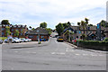
Alma Road, Brodick
Believed to be part of Alma road.
Image: © Billy McCrorie
Taken: 25 Jun 2018
0.01 miles
3
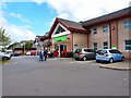
Co-op in Brodick
The biggest shop on Arran and a must visit store probably for most people on the island and every visitor.
Image: © Andy Farrington
Taken: 27 Jul 2012
0.02 miles
7
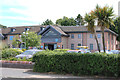
The Douglas Hotel, Brodick
http://www.thedouglashotel.co.uk/
Image: © Philip Cornwall
Taken: 27 Jun 2019
0.04 miles
10
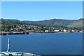
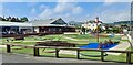
Brodick Town
View across towards the ferry terminal from the A841.
Image: © Andy Farrington
Taken: 27 Jul 2012
0.04 miles