IMAGES TAKEN NEAR TO
Barr, GIRVAN, KA26 9TY
Introduction
This page details the photographs taken nearby to KA26 9TY by members of the Geograph project.
The Geograph project started in 2005 with the aim of publishing, organising and preserving representative images for every square kilometre of Great Britain, Ireland and the Isle of Man.

There are currently over 7.5m images from over14,400 individuals and you can help contribute to the project by visiting https://www.geograph.org.uk
Image Map
Images are licensed for reuse under creativecommons.org/licenses/by-sa/2.0
Notes
- Clicking on the map will re-center to the selected point.
- The higher the marker number, the further away the image location is from the centre of the postcode.
Image Listing (4 Images Found)
Images are licensed for reuse under creativecommons.org/licenses/by-sa/2.0
Image
Details
Distance
1
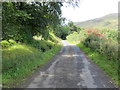
Road approaching Pynannot
Looking westward.
Image: © Peter Wood
Taken: 15 Sep 2017
0.09 miles
2
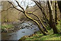
The River Stinchar
Looking upstream, a little way above Milton Bridge, on a fine but hazy April afternoon.
Image: © Mary and Angus Hogg
Taken: 19 Apr 2011
0.09 miles
4
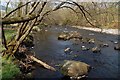
The River Stinchar
Looking downstream from a point just above Milton Bridge. Viewed on a fine April afternoon, before the foliage had opened out.
Image: © Mary and Angus Hogg
Taken: 19 Apr 2011
0.14 miles