IMAGES TAKEN NEAR TO
GIRVAN, KA26 9TQ
Introduction
This page details the photographs taken nearby to KA26 9TQ by members of the Geograph project.
The Geograph project started in 2005 with the aim of publishing, organising and preserving representative images for every square kilometre of Great Britain, Ireland and the Isle of Man.

There are currently over 7.5m images from over14,400 individuals and you can help contribute to the project by visiting https://www.geograph.org.uk
Image Map
Images are licensed for reuse under creativecommons.org/licenses/by-sa/2.0
Notes
- Clicking on the map will re-center to the selected point.
- The higher the marker number, the further away the image location is from the centre of the postcode.
Image Listing (21 Images Found)
Images are licensed for reuse under creativecommons.org/licenses/by-sa/2.0
Image
Details
Distance
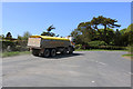
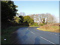
3
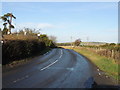
Road to Old Dailly at Penkill
The B734.
Image: © Billy McCrorie
Taken: 23 Nov 2012
0.03 miles
4
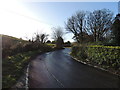
Road to the Barr at Penkill
The B734.
Image: © Billy McCrorie
Taken: 23 Nov 2012
0.03 miles
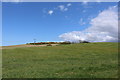
5
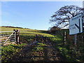
Farmland near Penkill
No, the Barr road is not up through the field.
Image: © Billy McCrorie
Taken: 23 Nov 2012
0.05 miles
7
Road to Old Dailly near Penkill
The B734.
Image: © Billy McCrorie
Taken: 23 Nov 2012
0.06 miles
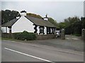
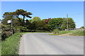
8
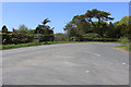
Junction of Old Dailly, Pinmore and Barr Roads
Image: © Billy McCrorie
Taken: 17 May 2018
0.06 miles