IMAGES TAKEN NEAR TO
Barr, GIRVAN, KA26 9TN
Introduction
This page details the photographs taken nearby to KA26 9TN by members of the Geograph project.
The Geograph project started in 2005 with the aim of publishing, organising and preserving representative images for every square kilometre of Great Britain, Ireland and the Isle of Man.

There are currently over 7.5m images from over14,400 individuals and you can help contribute to the project by visiting https://www.geograph.org.uk
Image Map
Images are licensed for reuse under creativecommons.org/licenses/by-sa/2.0
Notes
- Clicking on the map will re-center to the selected point.
- The higher the marker number, the further away the image location is from the centre of the postcode.
Image Listing (32 Images Found)
Images are licensed for reuse under creativecommons.org/licenses/by-sa/2.0
Image
Details
Distance
1
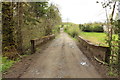
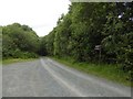
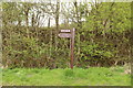
The Devil's Trail, Barr
Also the Changue Forest Trail.
Image: © Billy McCrorie
Taken: 13 May 2015
0.05 miles
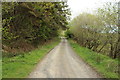
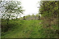
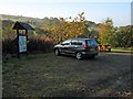
2
Approaching the Barr Trails Car Park
Image: © Billy McCrorie
Taken: 13 May 2015
0.05 miles
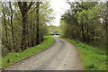
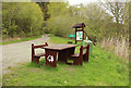
4
Forestry Commission car park, Changue
Some signposting of walks here, ideal if you like blanket conifers, although the road up to High Changue has good views.
Image: © Richard Webb
Taken: 18 Jun 2016
0.05 miles
6
Changue Forest Trail
From the Barr Trails car park.
Image: © Billy McCrorie
Taken: 13 May 2015
0.05 miles
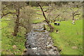
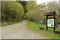
9
Barr Trails car park
There are a number of excellent walking and cycling trails in the Changue Forest. http://web.ukonline.co.uk/james.leil/Forest_Trails.html
Image: © Oliver Dixon
Taken: 16 Oct 2006
0.06 miles