IMAGES TAKEN NEAR TO
Woodside, GIRVAN, KA26 9SQ
Introduction
This page details the photographs taken nearby to Woodside, KA26 9SQ by members of the Geograph project.
The Geograph project started in 2005 with the aim of publishing, organising and preserving representative images for every square kilometre of Great Britain, Ireland and the Isle of Man.

There are currently over 7.5m images from over14,400 individuals and you can help contribute to the project by visiting https://www.geograph.org.uk
Image Map
Images are licensed for reuse under creativecommons.org/licenses/by-sa/2.0
Notes
- Clicking on the map will re-center to the selected point.
- The higher the marker number, the further away the image location is from the centre of the postcode.
Image Listing (159 Images Found)
Images are licensed for reuse under creativecommons.org/licenses/by-sa/2.0
Image
Details
Distance
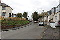
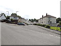
3
Bridge Street, Dailly
The white buildings are the new Ayrshire Housing.
Image: © Billy McCrorie
Taken: 26 Oct 2017
0.05 miles
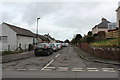
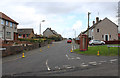
7
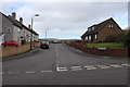
Wood Street, Dailly
From the junction with Bridge Street.
Image: © Billy McCrorie
Taken: 26 Jul 2012
0.06 miles
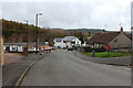
10
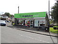
The Co-operative Food, Dailly
Store located on Bridge Street.
Image: © Billy McCrorie
Taken: 26 Jul 2012
0.08 miles