IMAGES TAKEN NEAR TO
Shanter Road, GIRVAN, KA26 9NL
Introduction
This page details the photographs taken nearby to Shanter Road, KA26 9NL by members of the Geograph project.
The Geograph project started in 2005 with the aim of publishing, organising and preserving representative images for every square kilometre of Great Britain, Ireland and the Isle of Man.

There are currently over 7.5m images from over14,400 individuals and you can help contribute to the project by visiting https://www.geograph.org.uk
Image Map
Images are licensed for reuse under creativecommons.org/licenses/by-sa/2.0
Notes
- Clicking on the map will re-center to the selected point.
- The higher the marker number, the further away the image location is from the centre of the postcode.
Image Listing (204 Images Found)
Images are licensed for reuse under creativecommons.org/licenses/by-sa/2.0
Image
Details
Distance

3
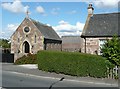
Maidens church
This is attached to Kirkoswald parish church, and services are held here on Easter Day and on alternate Sundays from the beginning of July until the end of August, according to http://www.kirkoswald.net/worship.html .
Image: © Humphrey Bolton
Taken: 8 Sep 2010
0.04 miles
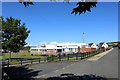
5
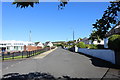
Shanter Road, Maidens
With Primary School on the left.
Image: © Billy McCrorie
Taken: 21 Jun 2019
0.04 miles
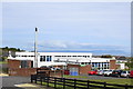
8
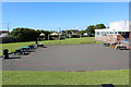
Playground at Maidens Primary School
Image: © Billy McCrorie
Taken: 21 Jun 2019
0.05 miles
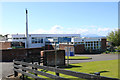
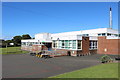
9
Maidens school
A modern building with a surprisingly tall chimney.
Image: © Humphrey Bolton
Taken: 8 Sep 2010
0.05 miles
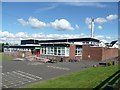
10
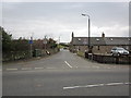
Shanter Road, Maidens
From the Kirkoswald Road.
Image: © Billy McCrorie
Taken: 1 Mar 2012
0.07 miles