IMAGES TAKEN NEAR TO
GIRVAN, KA26 9LB
Introduction
This page details the photographs taken nearby to KA26 9LB by members of the Geograph project.
The Geograph project started in 2005 with the aim of publishing, organising and preserving representative images for every square kilometre of Great Britain, Ireland and the Isle of Man.

There are currently over 7.5m images from over14,400 individuals and you can help contribute to the project by visiting https://www.geograph.org.uk
Image Map
Images are licensed for reuse under creativecommons.org/licenses/by-sa/2.0
Notes
- Clicking on the map will re-center to the selected point.
- The higher the marker number, the further away the image location is from the centre of the postcode.
Image Listing (3 Images Found)
Images are licensed for reuse under creativecommons.org/licenses/by-sa/2.0
Image
Details
Distance
1
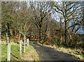
This Way to Glenmard Stables
This track isn't shown on the maps. It leads to Glenmard Stables. Viewed during a bright spell on a chilly March afternoon.
Image: © Mary and Angus Hogg
Taken: 1 Mar 2009
0.15 miles
2
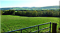
Girvan Valley view 2021
Not a lot has changed since the 1975 shot was taken. The trees have grown sufficiently to obscure some of the view and there’s a new gate at the field entrance. Although there has been a major wind-farm development on these hills, the turbines are out of sight from here being located just over the crest of the ridge. For a 1998 view, see Image
Image: © Mary and Angus Hogg
Taken: 15 Oct 2021
0.25 miles
3
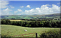
Girvan Valley view 1998
Looking towards Dailly and the hills beyond from the minor road near Glenlochrie. For a 2021 view, see Image
Image: © Mary and Angus Hogg
Taken: Unknown
0.25 miles