IMAGES TAKEN NEAR TO
GIRVAN, KA26 9JW
Introduction
This page details the photographs taken nearby to KA26 9JW by members of the Geograph project.
The Geograph project started in 2005 with the aim of publishing, organising and preserving representative images for every square kilometre of Great Britain, Ireland and the Isle of Man.

There are currently over 7.5m images from over14,400 individuals and you can help contribute to the project by visiting https://www.geograph.org.uk
Image Map (Loading...)


Getting Data...Please wait
Leaflet Map data © OpenStreetMap
Images are licensed for reuse under creativecommons.org/licenses/by-sa/2.0
Notes
- Clicking on the map will re-center to the selected point.
- The higher the marker number, the further away the image location is from the centre of the postcode.
Image Listing (112 Images Found)
Images are licensed for reuse under creativecommons.org/licenses/by-sa/2.0
Image
Details
Distance
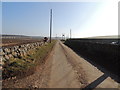
2
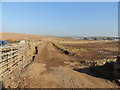
Farmland at Dowhill
On the mid right is Turnberry holiday park.
Image: © Billy McCrorie
Taken: 27 Feb 2013
0.02 miles
3
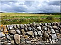
Dry stone wall, Dowhill
Looking north-east
Image: © Kenneth Allen
Taken: 25 Jul 2013
0.02 miles
6
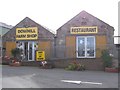
Dowhill Farm shop and Restaurant
A final stop here before we travelled south to reach the ferry for home.
Image: © Kenneth Allen
Taken: 28 Sep 2006
0.04 miles
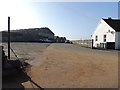
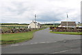
8
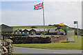
Flying the Flags at Dowhill
Dowhill Farm Shop and Restaurant next to the A77.
Image: © Billy McCrorie
Taken: 18 Jun 2022
0.05 miles
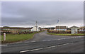
9
Road to Turnberry Holiday Park
From the A77.
Image: © Billy McCrorie
Taken: 19 Jun 2020
0.05 miles
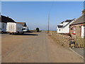
10
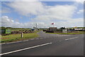
Road to Turnberry Holiday Park
Accessed from the A77.
Image: © Billy McCrorie
Taken: 18 Jun 2022
0.05 miles