IMAGES TAKEN NEAR TO
GIRVAN, KA26 9JE
Introduction
This page details the photographs taken nearby to KA26 9JE by members of the Geograph project.
The Geograph project started in 2005 with the aim of publishing, organising and preserving representative images for every square kilometre of Great Britain, Ireland and the Isle of Man.

There are currently over 7.5m images from over14,400 individuals and you can help contribute to the project by visiting https://www.geograph.org.uk
Image Map
Images are licensed for reuse under creativecommons.org/licenses/by-sa/2.0
Notes
- Clicking on the map will re-center to the selected point.
- The higher the marker number, the further away the image location is from the centre of the postcode.
Image Listing (181 Images Found)
Images are licensed for reuse under creativecommons.org/licenses/by-sa/2.0
Image
Details
Distance
2
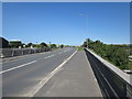
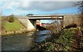
A77 Trunk Road
From bridge over river, road heads towards Turnberry/Maybole.
Image: © Billy McCrorie
Taken: 23 Jul 2011
0.02 miles
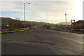
3
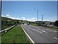
A77 Trunk Road
Trunk road heading for Girvan.
Image: © Billy McCrorie
Taken: 23 Jul 2011
0.02 miles
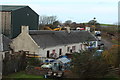
5
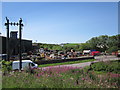
Vehicle Scrap Yard
Scrap yard at Bridgemill just off the A77.
Image: © Billy McCrorie
Taken: 23 Jul 2011
0.03 miles
7
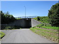
Road Bridge
Local traffic can go under the A77.
Image: © Billy McCrorie
Taken: 23 Jul 2011
0.03 miles
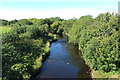
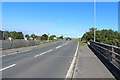
10
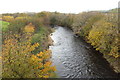
Bridge Over The Water Of Girvan
This modern bridge carries the A77 over the Water of Girvan. The old corn mill buildings are just visible in the background.
Image: © Mary and Angus Hogg
Taken: 22 Feb 2016
0.03 miles