IMAGES TAKEN NEAR TO
GIRVAN, KA26 9JD
Introduction
This page details the photographs taken nearby to KA26 9JD by members of the Geograph project.
The Geograph project started in 2005 with the aim of publishing, organising and preserving representative images for every square kilometre of Great Britain, Ireland and the Isle of Man.

There are currently over 7.5m images from over14,400 individuals and you can help contribute to the project by visiting https://www.geograph.org.uk
Image Map
Images are licensed for reuse under creativecommons.org/licenses/by-sa/2.0
Notes
- Clicking on the map will re-center to the selected point.
- The higher the marker number, the further away the image location is from the centre of the postcode.
Image Listing (89 Images Found)
Images are licensed for reuse under creativecommons.org/licenses/by-sa/2.0
Image
Details
Distance

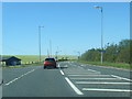
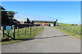
3
Ayrshire Coastal Path at Girvan Mains
With waymarker.
Image: © Billy McCrorie
Taken: 16 Sep 2015
0.04 miles
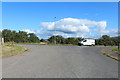
4

Ayrshire Coastal Path
Passing through Girvan Mains Farm.
Image: © Billy McCrorie
Taken: 6 Mar 2013
0.04 miles
5
Ayrshire Coastal Path at Girvan Mains
Image: © Billy McCrorie
Taken: 16 Sep 2015
0.04 miles
6

Golf Course Road
From the A77 at Girvan Mains.
Image: © Billy McCrorie
Taken: 6 Mar 2013
0.05 miles
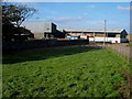
7
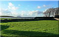
Girvan Mains View
A winter view of the coastal fields at Girvan Mains with Ailsa Craig in the background. This area holds the site of a Roman camp.
Image: © Mary and Angus Hogg
Taken: 19 Jan 2014
0.05 miles
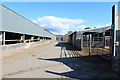
8

Golf Course Road
Approaching the A77, with Grant's Distillery up on the mid left.
Image: © Billy McCrorie
Taken: 6 Mar 2013
0.05 miles