IMAGES TAKEN NEAR TO
McConnell Square, GIRVAN, KA26 9HR
Introduction
This page details the photographs taken nearby to McConnell Square, KA26 9HR by members of the Geograph project.
The Geograph project started in 2005 with the aim of publishing, organising and preserving representative images for every square kilometre of Great Britain, Ireland and the Isle of Man.

There are currently over 7.5m images from over14,400 individuals and you can help contribute to the project by visiting https://www.geograph.org.uk
Image Map
Images are licensed for reuse under creativecommons.org/licenses/by-sa/2.0
Notes
- Clicking on the map will re-center to the selected point.
- The higher the marker number, the further away the image location is from the centre of the postcode.
Image Listing (3172 Images Found)
Images are licensed for reuse under creativecommons.org/licenses/by-sa/2.0
Image
Details
Distance
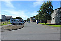
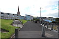
2
Park at McConnell Square, Girvan
Viewed from Montgomerie Street.
Image: © Billy McCrorie
Taken: 21 Jan 2022
0.01 miles
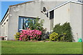
4
McConnell Square
Situated at the junction with Montgomerie Street just opposite the Royal Hotel.
Image: © Billy McCrorie
Taken: 23 Jul 2011
0.02 miles
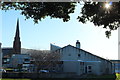
10

The Old High Street, Girvan
This end is Pedestrian only and a short stretch at the far end is a road onto Hamilton Street at Church Square.
Image: © Billy McCrorie
Taken: 21 Jan 2022
0.03 miles