IMAGES TAKEN NEAR TO
Killochan Street, GIRVAN, KA26 9EH
Introduction
This page details the photographs taken nearby to Killochan Street, KA26 9EH by members of the Geograph project.
The Geograph project started in 2005 with the aim of publishing, organising and preserving representative images for every square kilometre of Great Britain, Ireland and the Isle of Man.

There are currently over 7.5m images from over14,400 individuals and you can help contribute to the project by visiting https://www.geograph.org.uk
Image Map
Images are licensed for reuse under creativecommons.org/licenses/by-sa/2.0
Notes
- Clicking on the map will re-center to the selected point.
- The higher the marker number, the further away the image location is from the centre of the postcode.
Image Listing (846 Images Found)
Images are licensed for reuse under creativecommons.org/licenses/by-sa/2.0
Image
Details
Distance
1
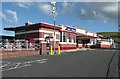
Girvan railway station
The main station building caught fire in January 1946 and was rebuilt in a typical 1930s LMS style, but not completed until August 1951. See http://en.wikipedia.org/wiki/Girvan_railway_station
Image: © Humphrey Bolton
Taken: 8 Sep 2010
0.01 miles
2
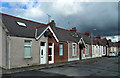
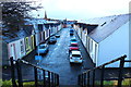
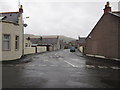
Killochan Colliery Houses
The houses in this area were built to accommodate local coal miners and were far ahead of their time in design and construction, significantly better than the typical miners' rows found elsewhere. This view shows Killochan Street, named after Killochan Pit, a few miles inland near Dailly. No mining takes place nowadays, the last local colliery having closed in 1977.
Image: © Mary and Angus Hogg
Taken: 10 Oct 2014
0.02 miles
3
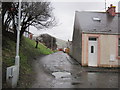
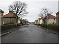
Bourtreehall Lane
Path at the end of Bourtreehall heading towards Penkill Road. Buildings up on the left is Girvan Railway Station.
Image: © Billy McCrorie
Taken: 4 Jan 2012
0.03 miles
7
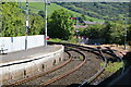
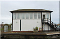
Railway Line, Girvan
Heading for Stranraer
Image: © Billy McCrorie
Taken: 4 Jun 2022
0.04 miles
8
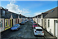
Bourtreehall
The houses in this area were built to accommodate local coal miners and were far ahead of their time in design and construction, significantly better than the typical miners' rows found elsewhere.
Image: © Mary and Angus Hogg
Taken: 10 Oct 2014
0.04 miles
9
Bourtreehall Street
Junction of Bourtreehall heading towards Killochan Street.
Image: © Billy McCrorie
Taken: 4 Jan 2012
0.04 miles
10
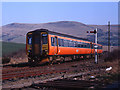
Train approaching Girvan station
A 2-car 156 set in Strathclyde PTE colours approaches Girvan station with the 15.16 passenger service from Stranraer to Ayr. For other views at Girvan station, see: Image & Image
Image: © The Carlisle Kid
Taken: 5 Apr 1996
0.04 miles