IMAGES TAKEN NEAR TO
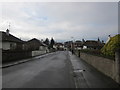
Troweir Road, GIRVAN, KA26 9EA
Introduction
This page details the photographs taken nearby to Troweir Road, KA26 9EA by members of the Geograph project.
The Geograph project started in 2005 with the aim of publishing, organising and preserving representative images for every square kilometre of Great Britain, Ireland and the Isle of Man.

There are currently over 7.5m images from over14,400 individuals and you can help contribute to the project by visiting https://www.geograph.org.uk
Image Map
Images are licensed for reuse under creativecommons.org/licenses/by-sa/2.0
Notes
- Clicking on the map will re-center to the selected point.
- The higher the marker number, the further away the image location is from the centre of the postcode.
Image Listing (317 Images Found)
Images are licensed for reuse under creativecommons.org/licenses/by-sa/2.0
Image
Details
Distance
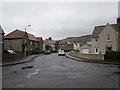
1
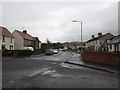
Troweir Road
From the junction with North Drive.
Image: © Billy McCrorie
Taken: 21 Feb 2012
0.01 miles
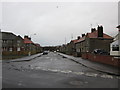
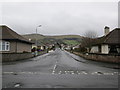
2
Troweir Road
Where North Drive meets Troweir Road.
Image: © Billy McCrorie
Taken: 21 Feb 2012
0.03 miles
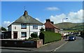
4
Penkill Road
From the junction with Troweir Road.
Image: © Billy McCrorie
Taken: 21 Feb 2012
0.06 miles
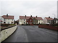
6
Lendal Quadrant
Local authority housing area, viewed at the junction with Troweir Road.
Image: © Mary and Angus Hogg
Taken: 30 Aug 2014
0.11 miles
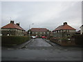
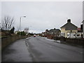
9
North Drive
In the direction of The Avenue.
Image: © Billy McCrorie
Taken: 21 Feb 2012
0.13 miles
10
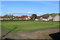
Mini Putting/Golf Course at Girvan Bowling Club
Four bowling greens now becomes three.
Image: © Billy McCrorie
Taken: 7 Sep 2019
0.14 miles