IMAGES TAKEN NEAR TO
The Avenue, GIRVAN, KA26 9DS
Introduction
This page details the photographs taken nearby to The Avenue, KA26 9DS by members of the Geograph project.
The Geograph project started in 2005 with the aim of publishing, organising and preserving representative images for every square kilometre of Great Britain, Ireland and the Isle of Man.

There are currently over 7.5m images from over14,400 individuals and you can help contribute to the project by visiting https://www.geograph.org.uk
Image Map
Images are licensed for reuse under creativecommons.org/licenses/by-sa/2.0
Notes
- Clicking on the map will re-center to the selected point.
- The higher the marker number, the further away the image location is from the centre of the postcode.
Image Listing (1209 Images Found)
Images are licensed for reuse under creativecommons.org/licenses/by-sa/2.0
Image
Details
Distance
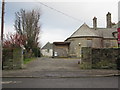
3
Richard Edmiston Way, Girvan
The entrance to the bowling greens, just off The Avenue.
Image: © Billy McCrorie
Taken: 24 Jul 2022
0.02 miles
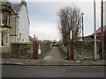
4
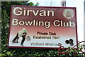
Girvan Bowling Club Name Sign
On The Avenue.
Image: © Billy McCrorie
Taken: 24 Jul 2022
0.02 miles
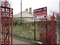
5
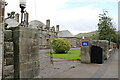
In Gate, Old Davidson Hospital
On The Avenue.
Image: © Billy McCrorie
Taken: 24 Jul 2022
0.02 miles
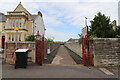
6
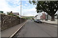
The Avenue, Girvan
Leading up to Coalpots Road. Viewed from the entrance to Orchard Gardens.
Image: © Billy McCrorie
Taken: 24 Jul 2022
0.02 miles
7
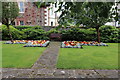
Orchard Gardens, Girvan
Viewed in late July (24th).
Image: © Billy McCrorie
Taken: 24 Jul 2022
0.02 miles
8
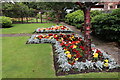
Colour at Orchard Gardens, Girvan
Viewed in late July (24th).
Image: © Billy McCrorie
Taken: 24 Jul 2022
0.02 miles
9
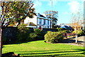
Orchard Gardens, Girvan
White building is the Southfield Hotel.
Image: © Billy McCrorie
Taken: 1 Nov 2016
0.02 miles