IMAGES TAKEN NEAR TO
Pinwherry, GIRVAN, KA26 0TZ
Introduction
This page details the photographs taken nearby to KA26 0TZ by members of the Geograph project.
The Geograph project started in 2005 with the aim of publishing, organising and preserving representative images for every square kilometre of Great Britain, Ireland and the Isle of Man.

There are currently over 7.5m images from over14,400 individuals and you can help contribute to the project by visiting https://www.geograph.org.uk
Image Map
Images are licensed for reuse under creativecommons.org/licenses/by-sa/2.0
Notes
- Clicking on the map will re-center to the selected point.
- The higher the marker number, the further away the image location is from the centre of the postcode.
Image Listing (39 Images Found)
Images are licensed for reuse under creativecommons.org/licenses/by-sa/2.0
Image
Details
Distance
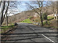


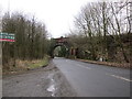
5
Railway Bridge Near Pinwherry
Railway bridge carrying the Ayr-Stranraer railway line over the A714
Image: © Iain Thompson
Taken: 21 Jul 2006
0.05 miles
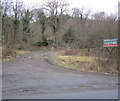
8
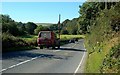
Going To Pinwherry
Traffic heading southwards on the A714 towards Pinwherry.
Image: © Mary and Angus Hogg
Taken: 15 Sep 2009
0.08 miles
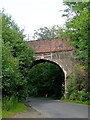
9
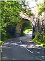
Laggansarroch Bridge
View of the rail bridge on the A714 that carries the Stranraer to Ayr railway line.
Image: © Andy Farrington
Taken: 30 Aug 2012
0.08 miles
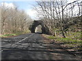
10
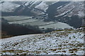
Railway Bridge over the River Stinchar
With view of Laggansarroch Farm.
Image: © Billy McCrorie
Taken: 22 Jan 2015
0.08 miles