IMAGES TAKEN NEAR TO
GIRVAN, KA26 0TT
Introduction
This page details the photographs taken nearby to KA26 0TT by members of the Geograph project.
The Geograph project started in 2005 with the aim of publishing, organising and preserving representative images for every square kilometre of Great Britain, Ireland and the Isle of Man.

There are currently over 7.5m images from over14,400 individuals and you can help contribute to the project by visiting https://www.geograph.org.uk
Image Map
Images are licensed for reuse under creativecommons.org/licenses/by-sa/2.0
Notes
- Clicking on the map will re-center to the selected point.
- The higher the marker number, the further away the image location is from the centre of the postcode.
Image Listing (8 Images Found)
Images are licensed for reuse under creativecommons.org/licenses/by-sa/2.0
Image
Details
Distance
1
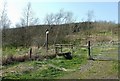
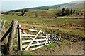
The Carrick Way
The signpost indicates the routes for Girvan and Barr.
Image: © Mary and Angus Hogg
Taken: 25 Mar 2012
0.02 miles
4
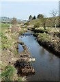
Water of Assel
The river, which is little more than a burn here, has eroded the bank on the left-hand side of this photo. The turbines of Hadyard Hill Wind Farm are visible in the distance.
Image: © Mary and Angus Hogg
Taken: 25 Mar 2012
0.18 miles
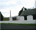
5
Barbae View
Barbae is the old farm on the crest of the hill in this view.
Image: © Mary and Angus Hogg
Taken: 25 Mar 2012
0.21 miles
6
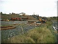
Surplus equipment at Tormitchell Quarry
Image: © Gordon Brown
Taken: 29 Oct 2006
0.23 miles
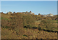
7
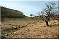
The Assel Valley
Looking towards the Water of Assel on a bright but hazy March morning.
Image: © Mary and Angus Hogg
Taken: 25 Mar 2012
0.23 miles
8
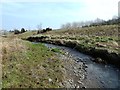
Water of Assel
This attractive burn joins the River Stinchar at Asselfoot, to the south of Pinmore.
Image: © Mary and Angus Hogg
Taken: 25 Mar 2012
0.25 miles