IMAGES TAKEN NEAR TO
Pinmore, GIRVAN, KA26 0TP
Introduction
This page details the photographs taken nearby to KA26 0TP by members of the Geograph project.
The Geograph project started in 2005 with the aim of publishing, organising and preserving representative images for every square kilometre of Great Britain, Ireland and the Isle of Man.

There are currently over 7.5m images from over14,400 individuals and you can help contribute to the project by visiting https://www.geograph.org.uk
Image Map
Images are licensed for reuse under creativecommons.org/licenses/by-sa/2.0
Notes
- Clicking on the map will re-center to the selected point.
- The higher the marker number, the further away the image location is from the centre of the postcode.
Image Listing (17 Images Found)
Images are licensed for reuse under creativecommons.org/licenses/by-sa/2.0
Image
Details
Distance
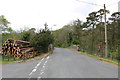
1
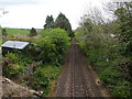
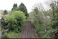
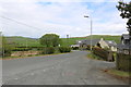
Pinmore railway station (site), Ayrshire
Opened in 1877 by the Girvan & Portpatrick Junction Railway, later part of the Glasgow & South Western Railway on what is today the line from Ayr to Stranraer, this station closed in 1965.
View south towards Pinwherry and Stranraer. The station building, now a private residence, lurks in the trees to the left of the line.
Image: © Nigel Thompson
Taken: 9 May 2019
0.04 miles