IMAGES TAKEN NEAR TO
Pinmore, GIRVAN, KA26 0TF
Introduction
This page details the photographs taken nearby to KA26 0TF by members of the Geograph project.
The Geograph project started in 2005 with the aim of publishing, organising and preserving representative images for every square kilometre of Great Britain, Ireland and the Isle of Man.

There are currently over 7.5m images from over14,400 individuals and you can help contribute to the project by visiting https://www.geograph.org.uk
Image Map
Images are licensed for reuse under creativecommons.org/licenses/by-sa/2.0
Notes
- Clicking on the map will re-center to the selected point.
- The higher the marker number, the further away the image location is from the centre of the postcode.
Image Listing (1 Images Found)
Images are licensed for reuse under creativecommons.org/licenses/by-sa/2.0
Image
Details
Distance
1
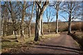
Beech Trees Above Traboyack Burn
A fine stand of beech trees at the corner of the access track for Lamdoughty Forest. Viewed in mid-March.
Image: © Mary and Angus Hogg
Taken: 19 Mar 2011
0.15 miles