IMAGES TAKEN NEAR TO
Pinwherry, GIRVAN, KA26 0SN
Introduction
This page details the photographs taken nearby to KA26 0SN by members of the Geograph project.
The Geograph project started in 2005 with the aim of publishing, organising and preserving representative images for every square kilometre of Great Britain, Ireland and the Isle of Man.

There are currently over 7.5m images from over14,400 individuals and you can help contribute to the project by visiting https://www.geograph.org.uk
Image Map
Images are licensed for reuse under creativecommons.org/licenses/by-sa/2.0
Notes
- Clicking on the map will re-center to the selected point.
- The higher the marker number, the further away the image location is from the centre of the postcode.
Image Listing (3 Images Found)
Images are licensed for reuse under creativecommons.org/licenses/by-sa/2.0
Image
Details
Distance
1
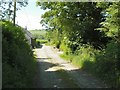
Cottage in a lane
The lane is the track leading to Glenduisk Image
Image: © James Allan
Taken: 7 Jun 2007
0.14 miles
2
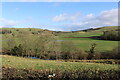
Farmland near Glenduisk
Viewed from the A714.
Image: © Billy McCrorie
Taken: 9 Feb 2022
0.16 miles
3
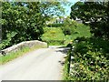
Bridge over Muck Water
Buildings in the background are part of Liglartrie.
Image: © James Allan
Taken: 7 Jun 2007
0.19 miles