IMAGES TAKEN NEAR TO
Pinwherry, GIRVAN, KA26 0SL
Introduction
This page details the photographs taken nearby to KA26 0SL by members of the Geograph project.
The Geograph project started in 2005 with the aim of publishing, organising and preserving representative images for every square kilometre of Great Britain, Ireland and the Isle of Man.

There are currently over 7.5m images from over14,400 individuals and you can help contribute to the project by visiting https://www.geograph.org.uk
Image Map
Images are licensed for reuse under creativecommons.org/licenses/by-sa/2.0
Notes
- Clicking on the map will re-center to the selected point.
- The higher the marker number, the further away the image location is from the centre of the postcode.
Image Listing (3 Images Found)
Images are licensed for reuse under creativecommons.org/licenses/by-sa/2.0
Image
Details
Distance
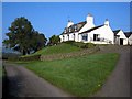
1
Fardenreoch Farm
Viewed from the A714.
Image: © Billy McCrorie
Taken: 9 Feb 2022
0.02 miles
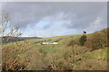
2
Fardenreoch
View across the Duisk River which runs behind the tree line in the middle of the picture to Fardenreoch Farm.
Image: © Andy Farrington
Taken: 2 Jun 2011
0.05 miles