IMAGES TAKEN NEAR TO
Pinwherry, GIRVAN, KA26 0RP
Introduction
This page details the photographs taken nearby to KA26 0RP by members of the Geograph project.
The Geograph project started in 2005 with the aim of publishing, organising and preserving representative images for every square kilometre of Great Britain, Ireland and the Isle of Man.

There are currently over 7.5m images from over14,400 individuals and you can help contribute to the project by visiting https://www.geograph.org.uk
Image Map
Images are licensed for reuse under creativecommons.org/licenses/by-sa/2.0
Notes
- Clicking on the map will re-center to the selected point.
- The higher the marker number, the further away the image location is from the centre of the postcode.
Image Listing (51 Images Found)
Images are licensed for reuse under creativecommons.org/licenses/by-sa/2.0
Image
Details
Distance
2
Bridge over the Railway at Ash Cottage
Image: © Billy McCrorie
Taken: 22 Jan 2015
0.02 miles
3
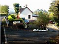
Ash Cottage, Pinwherry
On the A714, Girvan to Newton Stewart road.
Image: © Oliver Dixon
Taken: 15 Oct 2006
0.05 miles
4

Stagecoach Bus on the A714 in Winter
Approaching Ash Cottage.
Image: © Billy McCrorie
Taken: 22 Jan 2015
0.06 miles

6
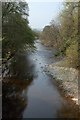
The River Stinchar
The River Stinchar, viewed from Daljarrock Bridge on a fine but hazy April day. This view will be lost when the foliage opens out on the trees.
Image: © Mary and Angus Hogg
Taken: 19 Apr 2011
0.14 miles

9
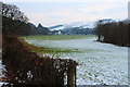
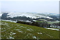
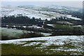
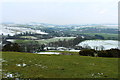
Farmland near Pinwherry
With view towards Daljarrock Hotel.
Image: © Billy McCrorie
Taken: 22 Jan 2015
0.17 miles
10
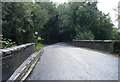
A714 crosses railway near Daljarrock Bridge
Image: © Colin Pyle
Taken: 24 Aug 2018
0.17 miles