IMAGES TAKEN NEAR TO
Main Street, GIRVAN, KA26 0RN
Introduction
This page details the photographs taken nearby to Main Street, KA26 0RN by members of the Geograph project.
The Geograph project started in 2005 with the aim of publishing, organising and preserving representative images for every square kilometre of Great Britain, Ireland and the Isle of Man.

There are currently over 7.5m images from over14,400 individuals and you can help contribute to the project by visiting https://www.geograph.org.uk
Image Map
Images are licensed for reuse under creativecommons.org/licenses/by-sa/2.0
Notes
- Clicking on the map will re-center to the selected point.
- The higher the marker number, the further away the image location is from the centre of the postcode.
Image Listing (69 Images Found)
Images are licensed for reuse under creativecommons.org/licenses/by-sa/2.0
Image
Details
Distance
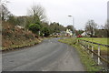
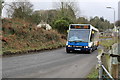
1
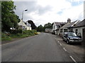
Pinwherry Village
The A714 to Newton Stewart.
Image: © Billy McCrorie
Taken: 5 Jul 2012
0.02 miles
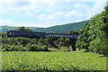
3
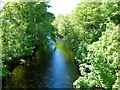
Duisk River
View of the river downstream taken from Pinwherry Bridge. The Duisk joins the River Stinchar lower down in Pinwherry.
Image: © Andy Farrington
Taken: 2 Jun 2011
0.05 miles
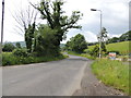
4
The Duisk River
Looking down the Duisk River from Pinwherry Bridge. The Duisk joins the Stinchar a little further downstream.
Image: © Mary and Angus Hogg
Taken: 3 Apr 2013
0.06 miles

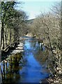
8

Confluence of the Duisk and the Stinchar
Image: © Billy McCrorie
Taken: 22 Jan 2015
0.07 miles
10

Confluence of the Duisk and the Stinchar
Image: © Billy McCrorie
Taken: 22 Jan 2015
0.07 miles