IMAGES TAKEN NEAR TO
Barrhill, GIRVAN, KA26 0RF
Introduction
This page details the photographs taken nearby to KA26 0RF by members of the Geograph project.
The Geograph project started in 2005 with the aim of publishing, organising and preserving representative images for every square kilometre of Great Britain, Ireland and the Isle of Man.

There are currently over 7.5m images from over14,400 individuals and you can help contribute to the project by visiting https://www.geograph.org.uk
Image Map
Images are licensed for reuse under creativecommons.org/licenses/by-sa/2.0
Notes
- Clicking on the map will re-center to the selected point.
- The higher the marker number, the further away the image location is from the centre of the postcode.
Image Listing (9 Images Found)
Images are licensed for reuse under creativecommons.org/licenses/by-sa/2.0
Image
Details
Distance
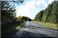
1
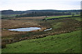
Looking towards Corwar Mains
Looking NW from position
Image: © Iain Macaulay
Taken: 8 Dec 2005
0.17 miles
3
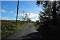
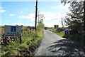
Corwar Mains
This small track next to the former Corwar School House leads down off the A714 to Corwar Mains Farm.
Image: © Andy Farrington
Taken: 2 Jun 2011
0.18 miles
6
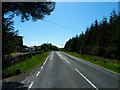
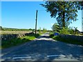
Corwar School House
View past the former school house left of picture along the A714 in the direction of Barrhill. The small track off to the left in the foreground leads down to Corwar Mains Farm.
Image: © Andy Farrington
Taken: 2 Jun 2011
0.19 miles
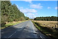
9
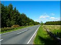
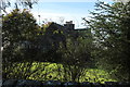
Corwar Mains
View along the A714 in the direction of Newton Stewart.
Image: © Andy Farrington
Taken: 2 Jun 2011
0.25 miles