IMAGES TAKEN NEAR TO
Barrhill, GIRVAN, KA26 0QH
Introduction
This page details the photographs taken nearby to KA26 0QH by members of the Geograph project.
The Geograph project started in 2005 with the aim of publishing, organising and preserving representative images for every square kilometre of Great Britain, Ireland and the Isle of Man.

There are currently over 7.5m images from over14,400 individuals and you can help contribute to the project by visiting https://www.geograph.org.uk
Image Map
Images are licensed for reuse under creativecommons.org/licenses/by-sa/2.0
Notes
- Clicking on the map will re-center to the selected point.
- The higher the marker number, the further away the image location is from the centre of the postcode.
Image Listing (6 Images Found)
Images are licensed for reuse under creativecommons.org/licenses/by-sa/2.0
Image
Details
Distance
1
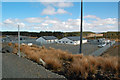
Arecleoch Wind Farm
Scottish Power Renewables' base at Arecleoch Wind Farm.
Image: © Mary and Angus Hogg
Taken: 19 Apr 2013
0.08 miles
2
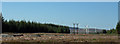
Wooden Pole
New electricity pole structure erected to carry cables from wind farm through cleared Arecleoch Forest.
Image: © J Scott
Taken: 2 Sep 2010
0.12 miles
3

Settled Water
Settlement pond back dropped by turbines of Arecleoch wind farm.
Image: © J Scott
Taken: 2 Sep 2010
0.12 miles
4
Arecleoch Wind Farm
Turbines of Arecleoch Wind Farm and a new road leading straight ahead. The older forestry road leads to the left in this shot.
Image: © Mary and Angus Hogg
Taken: 19 Apr 2013
0.15 miles
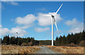
5
Tree Line
Wind turbine at the Arecleoch wind farm.
Image: © J Scott
Taken: 2 Sep 2010
0.18 miles
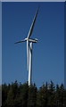
6
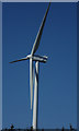
Blade Runner
Blades of wind turbine, Arecleoch wind farm.
Image: © J Scott
Taken: 2 Sep 2010
0.19 miles