IMAGES TAKEN NEAR TO
Pinwherry, GIRVAN, KA26 0QD
Introduction
This page details the photographs taken nearby to KA26 0QD by members of the Geograph project.
The Geograph project started in 2005 with the aim of publishing, organising and preserving representative images for every square kilometre of Great Britain, Ireland and the Isle of Man.

There are currently over 7.5m images from over14,400 individuals and you can help contribute to the project by visiting https://www.geograph.org.uk
Image Map
Images are licensed for reuse under creativecommons.org/licenses/by-sa/2.0
Notes
- Clicking on the map will re-center to the selected point.
- The higher the marker number, the further away the image location is from the centre of the postcode.
Image Listing (5 Images Found)
Images are licensed for reuse under creativecommons.org/licenses/by-sa/2.0
Image
Details
Distance
1
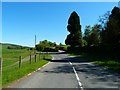
Alticane
View along the A714 towards High Alticane which is just off to the right.
Image: © Andy Farrington
Taken: 2 Jun 2011
0.04 miles
2
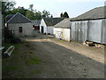
Farm beside railway bridge
Farm buildings squeezed neatly between main A714 road and railway.
Image: © James Allan
Taken: 7 Jun 2007
0.05 miles
3
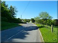
Alticane
View along the A714 towards Laigh Alticane Farm centre of picture.
Image: © Andy Farrington
Taken: 2 Jun 2011
0.07 miles
4
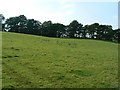
Trees on a ridge
Line of trees near Alticane.
Image: © James Allan
Taken: 7 Jun 2007
0.12 miles
5
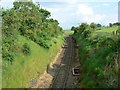
Single track main line
Section of the Stranraer to Glasgow railway, south of Alticane.
Image: © James Allan
Taken: 7 Jun 2007
0.20 miles