IMAGES TAKEN NEAR TO
Gowlands Terrace, GIRVAN, KA26 0PR
Introduction
This page details the photographs taken nearby to Gowlands Terrace, KA26 0PR by members of the Geograph project.
The Geograph project started in 2005 with the aim of publishing, organising and preserving representative images for every square kilometre of Great Britain, Ireland and the Isle of Man.

There are currently over 7.5m images from over14,400 individuals and you can help contribute to the project by visiting https://www.geograph.org.uk
Image Map
Images are licensed for reuse under creativecommons.org/licenses/by-sa/2.0
Notes
- Clicking on the map will re-center to the selected point.
- The higher the marker number, the further away the image location is from the centre of the postcode.
Image Listing (212 Images Found)
Images are licensed for reuse under creativecommons.org/licenses/by-sa/2.0
Image
Details
Distance
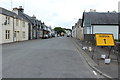
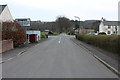
1
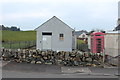
Gowlands terrace.
Looking towards the cross roads, the Memorial hall can be seen on the left.
Image: © The liverpool boys
Taken: 9 Sep 2007
0.01 miles
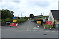
5
Gowlands Terrace, Barrhill
Also the road to Barrhill Railway Station.
Image: © Billy McCrorie
Taken: 10 Aug 2020
0.04 miles
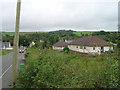
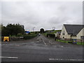
6
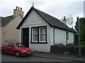
Old Bank building, Main street, Barrhill.
This ex bank is now a holiday home.
Image: © The liverpool boys
Taken: 8 Sep 2007
0.05 miles
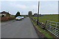
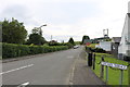
8
Gowlands Terrace
At the junction with the A714, this road also leads up to Barrhill railway station.
Image: © Billy McCrorie
Taken: 9 Jul 2012
0.05 miles