IMAGES TAKEN NEAR TO
Foreland, GIRVAN, KA26 0NQ
Introduction
This page details the photographs taken nearby to Foreland, KA26 0NQ by members of the Geograph project.
The Geograph project started in 2005 with the aim of publishing, organising and preserving representative images for every square kilometre of Great Britain, Ireland and the Isle of Man.

There are currently over 7.5m images from over14,400 individuals and you can help contribute to the project by visiting https://www.geograph.org.uk
Image Map
Images are licensed for reuse under creativecommons.org/licenses/by-sa/2.0
Notes
- Clicking on the map will re-center to the selected point.
- The higher the marker number, the further away the image location is from the centre of the postcode.
Image Listing (1215 Images Found)
Images are licensed for reuse under creativecommons.org/licenses/by-sa/2.0
Image
Details
Distance
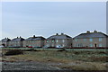
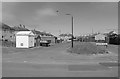
3
Foreland, Ballantrae
Mid left is a view of the Ailsa Craig.
Image: © Billy McCrorie
Taken: 9 Jul 2018
0.01 miles
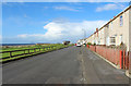
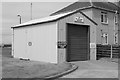
4
Foreland, Ballantrae
You can just see the Harbour wall on the mid left and the outline beyond is the Isle of Arran. Lovely sunny evening but all is quiet thanks to the Coronavirus.
Image: © Billy McCrorie
Taken: 20 Apr 2020
0.01 miles
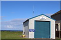
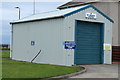
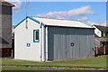
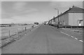
10
Coastguard Station, Ballantrae
At the corner of Shore Road and the Foreland.
Image: © Billy McCrorie
Taken: 27 Oct 2020
0.01 miles