IMAGES TAKEN NEAR TO
Ailsa Drive, GIRVAN, KA26 0NL
Introduction
This page details the photographs taken nearby to Ailsa Drive, KA26 0NL by members of the Geograph project.
The Geograph project started in 2005 with the aim of publishing, organising and preserving representative images for every square kilometre of Great Britain, Ireland and the Isle of Man.

There are currently over 7.5m images from over14,400 individuals and you can help contribute to the project by visiting https://www.geograph.org.uk
Image Map (Loading...)


Getting Data...Please wait
Leaflet Map data © OpenStreetMap
Images are licensed for reuse under creativecommons.org/licenses/by-sa/2.0
Notes
- Clicking on the map will re-center to the selected point.
- The higher the marker number, the further away the image location is from the centre of the postcode.
Image Listing (1196 Images Found)
Images are licensed for reuse under creativecommons.org/licenses/by-sa/2.0
Image
Details
Distance
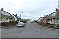
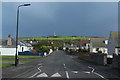
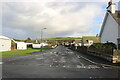
1

Ailsa Drive, Ballantrae
With a light covering of snow in mid February, viewed from the Shore Road.
Image: © Billy McCrorie
Taken: 13 Feb 2021
0.01 miles
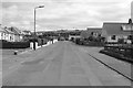
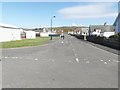
9
Shore Road, Ballantrae
Heading for the A77.
Image: © Billy McCrorie
Taken: 8 Jul 2020
0.02 miles
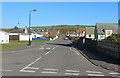
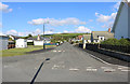
10
Shore Road, Ballantrae
Leading to the A77. First building on the left is the Coastguard Station.
Image: © Billy McCrorie
Taken: 27 Oct 2020
0.02 miles