IMAGES TAKEN NEAR TO
Mains Road, GIRVAN, KA26 0LA
Introduction
This page details the photographs taken nearby to Mains Road, KA26 0LA by members of the Geograph project.
The Geograph project started in 2005 with the aim of publishing, organising and preserving representative images for every square kilometre of Great Britain, Ireland and the Isle of Man.

There are currently over 7.5m images from over14,400 individuals and you can help contribute to the project by visiting https://www.geograph.org.uk
Image Map
Images are licensed for reuse under creativecommons.org/licenses/by-sa/2.0
Notes
- Clicking on the map will re-center to the selected point.
- The higher the marker number, the further away the image location is from the centre of the postcode.
Image Listing (48 Images Found)
Images are licensed for reuse under creativecommons.org/licenses/by-sa/2.0
Image
Details
Distance
1
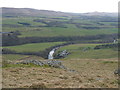
Macherquhat Farm
Farm at the bottom of Knockdolian with view over to the Smyrton Hills.
Image: © Billy McCrorie
Taken: 26 Jan 2011
0.01 miles
3
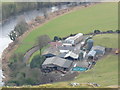
Macherquhat Farm
Close up of farm from Knockdolian. River on the left is the Stinchar.
Image: © Billy McCrorie
Taken: 26 Jan 2011
0.01 miles
4
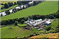
Macherquhat Farm
A farm by the B7044 at the foot of Knockdolian with the River Stinchar at the top left corner.
Image: © Walter Baxter
Taken: 11 Sep 2009
0.01 miles
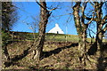
8
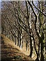
Bright Beech Boughs
The early morning sun highlighting bare Beech boughs in the Stinchar valley.
Image: © James T M Towill
Taken: 1 Dec 2013
0.04 miles
10
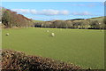
Farmland at Macherquhat
With Sheep.
Image: © Billy McCrorie
Taken: 14 Feb 2015
0.07 miles