IMAGES TAKEN NEAR TO
Ballantrae, GIRVAN, KA26 0JU
Introduction
This page details the photographs taken nearby to KA26 0JU by members of the Geograph project.
The Geograph project started in 2005 with the aim of publishing, organising and preserving representative images for every square kilometre of Great Britain, Ireland and the Isle of Man.

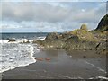
There are currently over 7.5m images from over14,400 individuals and you can help contribute to the project by visiting https://www.geograph.org.uk
Image Map
Images are licensed for reuse under creativecommons.org/licenses/by-sa/2.0
Notes
- Clicking on the map will re-center to the selected point.
- The higher the marker number, the further away the image location is from the centre of the postcode.
Image Listing (121 Images Found)
Images are licensed for reuse under creativecommons.org/licenses/by-sa/2.0
Image
Details
Distance
2
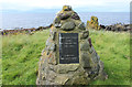
Memorial Cairn to Snib
Henry Ewing Torbet. View towards Ballantrae.
Image: © Billy McCrorie
Taken: 26 Aug 2017
0.02 miles
3
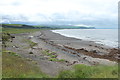
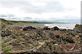
Bennane Lea
The pinkish and greenish rocks here are serpenitised ocean-floor rocks uplifted to land as part of the Ballantrae Ophiolite.
Image: © Anne Burgess
Taken: 26 Sep 2020
0.02 miles
4
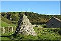
Commemorative Cairn
The cairn was built by local people in memory of Henry Ewing Torbet (1911-1983) who lived for many years in Bennane Cave nearby.
Image: © Anne Burgess
Taken: 26 Sep 2020
0.02 miles
5
Rock outcrops
The rock outcrops on the shore at Bennane Lea are a delight. Isolated blocks of reddened ultramafic rock are almost covered by sand before the stacks comprising basaltic tuff and breccia mark the end of the long, sandy shore to the south.
Image: © Jonathan Wilkins
Taken: 14 Sep 2023
0.03 miles
6
Memorial Cairn to Snib
Henry Ewing Torbet.
Image: © Billy McCrorie
Taken: 26 Aug 2017
0.03 miles
7
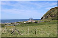
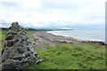
Houses at Bennane Lea
Above the houses is the Ailsa Craig.
Image: © Billy McCrorie
Taken: 30 May 2020
0.04 miles
8
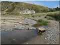
Houses and stream, Bennane Lea
Looking from the stream to houses by the old A77 road.
Image: © Jonathan Wilkins
Taken: 9 Sep 2023
0.04 miles
10
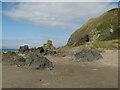
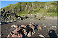
Sea stacks and cave
Fabulous, abandoned sea stacks are just above the modern tide level at the foot of cliffs on Bennane Hill. There is little evidence of the raised beach here because of its limited extent on the steep cliffs and disturbance by road construction. The rocks are varied in colour from red to green and blue, reflecting the alteration of ultramafic rocks which belong to the Ballantrae Ophiolite Complex.
Image: © Jonathan Wilkins
Taken: 9 Sep 2023
0.04 miles