IMAGES TAKEN NEAR TO
Lendalfoot, GIRVAN, KA26 0JP
Introduction
This page details the photographs taken nearby to KA26 0JP by members of the Geograph project.
The Geograph project started in 2005 with the aim of publishing, organising and preserving representative images for every square kilometre of Great Britain, Ireland and the Isle of Man.

There are currently over 7.5m images from over14,400 individuals and you can help contribute to the project by visiting https://www.geograph.org.uk
Image Map
Images are licensed for reuse under creativecommons.org/licenses/by-sa/2.0
Notes
- Clicking on the map will re-center to the selected point.
- The higher the marker number, the further away the image location is from the centre of the postcode.
Image Listing (152 Images Found)
Images are licensed for reuse under creativecommons.org/licenses/by-sa/2.0
Image
Details
Distance
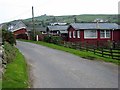
3
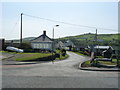
Road in Lendalfoot
Leading from the A77 to the A714 at Pinmore.
Image: © Billy McCrorie
Taken: 20 Jun 2023
0.05 miles
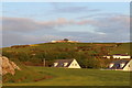
4
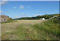
Lendalfoot Village
Road leading from the coastal village of Lendalfoot over the hill to Pinmore.
Image: © Billy McCrorie
Taken: 3 Jun 2011
0.05 miles
5
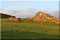
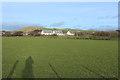
Farmland at Lendalfoot
Deafstone on the left and houses on the right. Viewed in late June (20th).
Image: © Billy McCrorie
Taken: 20 Jun 2023
0.05 miles
6
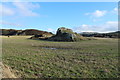
The Deafstone, Lendalfoot
To the left of the rock is an old ruin.
Image: © Billy McCrorie
Taken: 9 Nov 2014
0.07 miles

9
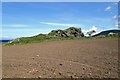
The Deafstone at Lendalfoot
This large rock is situated on the east side of the A77 on a raised beach.
Image: © Walter Baxter
Taken: 28 Apr 2018
0.07 miles