IMAGES TAKEN NEAR TO
GIRVAN, KA26 0JD
Introduction
This page details the photographs taken nearby to KA26 0JD by members of the Geograph project.
The Geograph project started in 2005 with the aim of publishing, organising and preserving representative images for every square kilometre of Great Britain, Ireland and the Isle of Man.

There are currently over 7.5m images from over14,400 individuals and you can help contribute to the project by visiting https://www.geograph.org.uk
Image Map
Images are licensed for reuse under creativecommons.org/licenses/by-sa/2.0
Notes
- Clicking on the map will re-center to the selected point.
- The higher the marker number, the further away the image location is from the centre of the postcode.
Image Listing (8 Images Found)
Images are licensed for reuse under creativecommons.org/licenses/by-sa/2.0
Image
Details
Distance
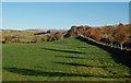
1

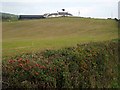
Farmland near Cundry Mains
A winter view in the Lendal Valley.
Image: © Mary and Angus Hogg
Taken: 16 Jan 2022
0.06 miles
3
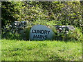
Cundry Mains
Nice piece of stone with farm name.
Image: © Billy McCrorie
Taken: 3 Jun 2011
0.09 miles
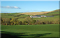
4

Cundry Mains farmland
A winter view in the lower Lendal Valley.
Image: © Mary and Angus Hogg
Taken: 16 Jan 2022
0.13 miles
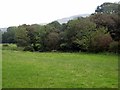
6
Towards Cundry Mains
An early-November view looking across the Lendal Water valley towards Cundry Mains. This farm lies on the other side of the valley and in another square.
Image: © Mary and Angus Hogg
Taken: 1 Nov 2016
0.15 miles
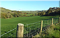
7
Lendal Valley View
An early-November view looking up the Water of Lendal from the Knockdaw Farm access road.
Image: © Mary and Angus Hogg
Taken: 1 Nov 2016
0.16 miles
8
Knockdaw View
An early-November view looking up the Water of Lendal near Knockdaw Farm.
Image: © Mary and Angus Hogg
Taken: 1 Nov 2016
0.19 miles