IMAGES TAKEN NEAR TO
Pinmore, GIRVAN, KA26 0HZ
Introduction
This page details the photographs taken nearby to KA26 0HZ by members of the Geograph project.
The Geograph project started in 2005 with the aim of publishing, organising and preserving representative images for every square kilometre of Great Britain, Ireland and the Isle of Man.

There are currently over 7.5m images from over14,400 individuals and you can help contribute to the project by visiting https://www.geograph.org.uk
Image Map
Images are licensed for reuse under creativecommons.org/licenses/by-sa/2.0
Notes
- Clicking on the map will re-center to the selected point.
- The higher the marker number, the further away the image location is from the centre of the postcode.
Image Listing (8 Images Found)
Images are licensed for reuse under creativecommons.org/licenses/by-sa/2.0
Image
Details
Distance
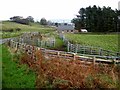
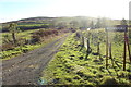
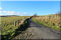
2
High Letterpin
Beware of the dogs!
Image: © Mark Nightingale
Taken: 23 Feb 2009
0.09 miles
6
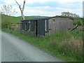
Ancient Railway Carriage
It's difficult to put a date on this old carriage, but it's a wooden construction, with individual compartments and no corridor. Inside there are still the small roughened patches beside the windows for passengers to strike their matches, and the penalty for improper use of the emergency chain was £5.
Image: © Mary and Angus Hogg
Taken: 20 May 2008
0.23 miles
8
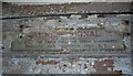
Ancient Alarm Signal
There's not much left to see inside the old railway carriage at Chapelcroft. The size of the fine for improper use of the emergency chain gives some idea of the vehicle's age.
Image: © Mary and Angus Hogg
Taken: 20 May 2008
0.24 miles