IMAGES TAKEN NEAR TO
Torcy Way, GIRVAN, KA26 0EY
Introduction
This page details the photographs taken nearby to Torcy Way, KA26 0EY by members of the Geograph project.
The Geograph project started in 2005 with the aim of publishing, organising and preserving representative images for every square kilometre of Great Britain, Ireland and the Isle of Man.

There are currently over 7.5m images from over14,400 individuals and you can help contribute to the project by visiting https://www.geograph.org.uk
Image Map
Images are licensed for reuse under creativecommons.org/licenses/by-sa/2.0
Notes
- Clicking on the map will re-center to the selected point.
- The higher the marker number, the further away the image location is from the centre of the postcode.
Image Listing (128 Images Found)
Images are licensed for reuse under creativecommons.org/licenses/by-sa/2.0
Image
Details
Distance
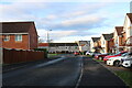
1
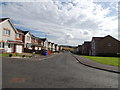
Torcy Way, Girvan
From the junction with Torcy Drive.
Image: © Billy McCrorie
Taken: 2 Aug 2012
0.02 miles
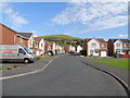
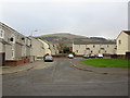
2
Springfields, Girvan
New private housing estate in Girvan.
Image: © Billy McCrorie
Taken: 2 Aug 2012
0.04 miles
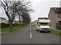
4
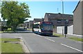
Coalpots Road
The back road, used by light traffic as an unofficial by-pass and by heavy traffic to avoid the low railway bridge in Image
Image: © Mary and Angus Hogg
Taken: 15 May 2008
0.04 miles
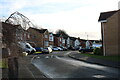
5
Torcy Drive, Girvan
Private Housing Estate, viewed on Christmas Eve.
Image: © Billy McCrorie
Taken: 24 Dec 2021
0.04 miles
7
Torcy Drive, Girvan
Private Housing Estate, viewed on Christmas Eve.
Image: © Billy McCrorie
Taken: 24 Dec 2021
0.05 miles
9
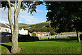
Housing Estate
Some of the council houses on the lower slopes of Doune Hill.
Image: © Anne Burgess
Taken: 25 Sep 2020
0.06 miles
