IMAGES TAKEN NEAR TO
Ballochtoul, GIRVAN, KA26 0EW
Introduction
This page details the photographs taken nearby to Ballochtoul, KA26 0EW by members of the Geograph project.
The Geograph project started in 2005 with the aim of publishing, organising and preserving representative images for every square kilometre of Great Britain, Ireland and the Isle of Man.

There are currently over 7.5m images from over14,400 individuals and you can help contribute to the project by visiting https://www.geograph.org.uk
Image Map
Images are licensed for reuse under creativecommons.org/licenses/by-sa/2.0
Notes
- Clicking on the map will re-center to the selected point.
- The higher the marker number, the further away the image location is from the centre of the postcode.
Image Listing (172 Images Found)
Images are licensed for reuse under creativecommons.org/licenses/by-sa/2.0
Image
Details
Distance
1
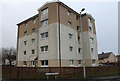
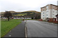
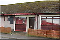
Ballochtoul Flats, Girvan
At the corner of Coalpots Road and South Park Avenue.
Image: © Billy McCrorie
Taken: 21 Dec 2017
0.00 miles
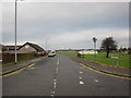
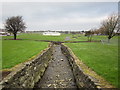
10
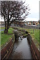
The Doune Burn, Girvan
The building site in the background is the new Invergarven school site.
Image: © Billy McCrorie
Taken: 21 Dec 2017
0.02 miles