IMAGES TAKEN NEAR TO
Firth Terrace, GIRVAN, KA26 0AG
Introduction
This page details the photographs taken nearby to Firth Terrace, KA26 0AG by members of the Geograph project.
The Geograph project started in 2005 with the aim of publishing, organising and preserving representative images for every square kilometre of Great Britain, Ireland and the Isle of Man.

There are currently over 7.5m images from over14,400 individuals and you can help contribute to the project by visiting https://www.geograph.org.uk
Image Map
Images are licensed for reuse under creativecommons.org/licenses/by-sa/2.0
Notes
- Clicking on the map will re-center to the selected point.
- The higher the marker number, the further away the image location is from the centre of the postcode.
Image Listing (405 Images Found)
Images are licensed for reuse under creativecommons.org/licenses/by-sa/2.0
Image
Details
Distance
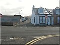
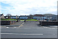
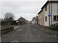
2
Firth Terrace, Girvan
Used to be called Gas Lane many moons ago.
Image: © Billy McCrorie
Taken: 25 Jun 2019
0.01 miles
3
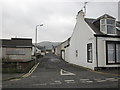
Firth Terrace
Terrace from the junction with Henrietta St, used to be called Gas Lane.
Image: © Billy McCrorie
Taken: 8 Nov 2011
0.02 miles
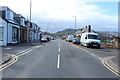
4
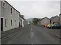
Ballybroke Street
Street from the junction with Firth Terr, hill in the distance is the Byne hill.
Image: © Billy McCrorie
Taken: 8 Nov 2011
0.02 miles
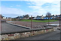
7
Site of the Old Girvan Medical Centre
Image: © Billy McCrorie
Taken: 25 Jun 2019
0.03 miles
9
Wilson Street
Taken from the junction with Firth Terr.
Image: © Billy McCrorie
Taken: 8 Nov 2011
0.03 miles
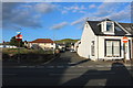
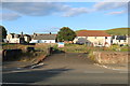
10

Ballybroke Street (2)
Cottages and commercial properties in Ballybroke Street. It is extraordinary to find such well-kept houses adjacent to grave dereliction.
Image: © Jonathan Wilkins
Taken: 3 Sep 2023
0.03 miles