IMAGES TAKEN NEAR TO
Moorpark Place, KILBIRNIE, KA25 7LN
Introduction
This page details the photographs taken nearby to Moorpark Place, KA25 7LN by members of the Geograph project.
The Geograph project started in 2005 with the aim of publishing, organising and preserving representative images for every square kilometre of Great Britain, Ireland and the Isle of Man.

There are currently over 7.5m images from over14,400 individuals and you can help contribute to the project by visiting https://www.geograph.org.uk
Image Map
Images are licensed for reuse under creativecommons.org/licenses/by-sa/2.0
Notes
- Clicking on the map will re-center to the selected point.
- The higher the marker number, the further away the image location is from the centre of the postcode.
Image Listing (15 Images Found)
Images are licensed for reuse under creativecommons.org/licenses/by-sa/2.0
Image
Details
Distance
1
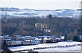
Moorpark House, Kilbirnie, North Ayrshire
Moorpark House as seen from near Kaimhill.
DSM and St. Margarets church in Dalry can be seen in the distance.
Image: © Mark S
Taken: 2 Feb 2019
0.11 miles
2
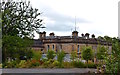
Moorpark House, Kilbirnie, North Ayrshire
The rear of the Category B-listed mansion showing the modern conservatory.
Image: © Mark S
Taken: 26 Jul 2019
0.11 miles
3
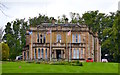
Moorpark House, Kilbirnie, North Ayrshire
Category B-listed Italianate mansion, built for William Knox of Kilbirnie in 1860.
Cunninghame District Council acquired the building in the 1980s and used it as a training and conference centre until it was sold off in 2003. After four years of refurbishments, Moorpark House opened as a luxury hotel in 2007, latterly becoming a popular wedding venue. The hotel closed in September 2016 and the building is now in use as a residential care home.
One of the few surviving original rooms in the house is the dining room, complete with its gold-leaf ceiling, hand painted by Italian craftsmen.
Image: © Mark S
Taken: 23 Jul 2019
0.12 miles
4
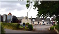
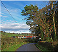
Baillieston Farm, Kilbirnie, North Ayrshire
Situated near Moorpark House, Baillieston Farm appears on the 1855 Ordnance Survey map, but dates back to at least 1821.
Image: © Mark S
Taken: 26 Jul 2019
0.13 miles
5
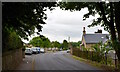
Milton Road, Kilbirnie, North Ayrshire
Glenside villa to the right of the picture first appears on an 1895 map of the town.
Image: © Mark S
Taken: 9 Jun 2020
0.13 miles
6
Baillieston Cottage and Farm
Viewed from Moorpark Road, Kilbirnie.
Image: © wfmillar
Taken: 30 Oct 2008
0.14 miles
7
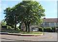
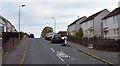
Milton Road
Milton Quadrant is on the right
Image: © Thomas Nugent
Taken: 13 Apr 2020
0.14 miles
9
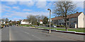
Stockbridge Crescent, Kilbirnie, North Ayrshire
Stockbridge Crescent is part of the Milton scheme in Kilbirnie. Construction began in 1949 and took several years to complete.
Image: © Mark S
Taken: 17 Oct 2020
0.16 miles
10
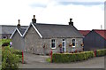
Baillieston Cottage, Kilbirnie, North Ayrshire
Next to Baillieston Farm, but built sometime later, appearing on the Ordnance Survey map in 1897.
Image: © Mark S
Taken: 26 Jul 2019
0.16 miles