IMAGES TAKEN NEAR TO
Steven Place, KILBIRNIE, KA25 7JQ
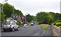
Introduction
This page details the photographs taken nearby to Steven Place, KA25 7JQ by members of the Geograph project.
The Geograph project started in 2005 with the aim of publishing, organising and preserving representative images for every square kilometre of Great Britain, Ireland and the Isle of Man.

There are currently over 7.5m images from over14,400 individuals and you can help contribute to the project by visiting https://www.geograph.org.uk
Image Map
Images are licensed for reuse under creativecommons.org/licenses/by-sa/2.0
Notes
- Clicking on the map will re-center to the selected point.
- The higher the marker number, the further away the image location is from the centre of the postcode.
Image Listing (65 Images Found)
Images are licensed for reuse under creativecommons.org/licenses/by-sa/2.0
Image
Details
Distance
1

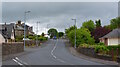
Stoneyholm Road, Kilbirnie, North Ayrshire
Dipple Road is second on the right.
Image: © Mark S
Taken: 17 Oct 2020
0.04 miles
2
Stoneyholm Road, Kilbirnie, North Ayrshire
The view looking up Stoneyholm Road as the A760 leaves Kilbirnie.
Image: © Mark S
Taken: 4 Jul 2020
0.04 miles
3
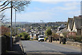
Stoneyholm Road
Looking towards the town centre.
Image: © Thomas Nugent
Taken: 13 Apr 2020
0.05 miles
4
Stoneyholm Road
Looking towards the town centre.
Image: © Thomas Nugent
Taken: 13 Apr 2020
0.06 miles
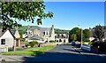
5
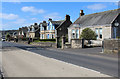
Steven Place, Kilbirnie, North Ayrshire
Construction of the development started around 2004.
This is the view from Dipple Road.
Image: © Mark S
Taken: 13 Jun 2020
0.07 miles
6
Stoneyholm Road, Kilbirnie, North Ayrshire
This part of Stoneyholm Road lies just off the A760, opposite Dipple Road.
Image: © Mark S
Taken: 13 Jun 2020
0.09 miles
7
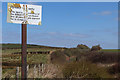
British Railways Board sign
An old BRB trespass sign by the A760 Stoneyholm Road bridge over the long disused Lochwinnoch Loop Line.
See also Image
Image: © Thomas Nugent
Taken: 13 Apr 2020
0.10 miles
8
Stoneyholm Road, Kilbirnie, North Ayrshire
Looking along Stoneyholm Road towards the A760.
Image: © Mark S
Taken: 29 Aug 2020
0.10 miles
9
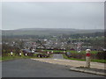
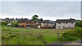
Kilbirnie, North Ayrshire
Kilbirnie, North Ayrshire as seen from the A760.
St Columba’s church can be seen in the centre of the picture and to the top right, houses on Geirston Road. The newer houses to the middle right of the picture were built on the site of the former Ladyland school.
Dominating the background is the Kelburn Wind Farm which was still under construction when this photograph was taken.
Image: © Mark S
Taken: 10 Mar 2012
0.10 miles
10
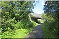
A760 bridge
The bridge had been modernised whilst the railway was still here.
Image: © Richard Webb
Taken: 1 Sep 2015
0.10 miles