IMAGES TAKEN NEAR TO
Broster Meadows, KILBIRNIE, KA25 7JG
Introduction
This page details the photographs taken nearby to Broster Meadows, KA25 7JG by members of the Geograph project.
The Geograph project started in 2005 with the aim of publishing, organising and preserving representative images for every square kilometre of Great Britain, Ireland and the Isle of Man.

There are currently over 7.5m images from over14,400 individuals and you can help contribute to the project by visiting https://www.geograph.org.uk
Image Map
Images are licensed for reuse under creativecommons.org/licenses/by-sa/2.0
Notes
- Clicking on the map will re-center to the selected point.
- The higher the marker number, the further away the image location is from the centre of the postcode.
Image Listing (33 Images Found)
Images are licensed for reuse under creativecommons.org/licenses/by-sa/2.0
Image
Details
Distance
1

Redheugh House, Kilbirnie
Built for Bryce Muir Knox of the Knox family of Kilbirnie in the late 19th century.
Later, the house was gifted to the Salvation Army who ran it as a hostel.
The building was converted into separate apartments around 2000.
Image: © Mark S
Taken: 19 Jan 2019
0.05 miles
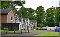
2
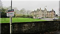
Redheugh
The large building looks like a residential home and is not the property for sale. The sale board refrers to a terraced house at £139,995 fixed price.
Image: © Richard Webb
Taken: 15 Oct 2011
0.05 miles
3
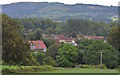
Kilbirnie North & Beith from near Chapelton Farm
Overlooking the north of Kilbirnie from near Chapelton Farm. Beith is in the distance, with Lomond Crescent and the newly built Melville Gardens visible.
Image: © Mark S
Taken: 26 Jul 2019
0.05 miles
4
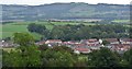
Kilbirnie North & Beith, North Ayrshire
Panoramic view across Kilbirnie North and over towards Beith, from High Boydstane.
Image: © Mark S
Taken: 26 Jul 2019
0.05 miles
5
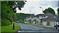
Redheugh Avenue, Kilbirnie, North Ayrshire
Housing development built around 2003 in the grounds of the Redheugh Estate.
Image: © Mark S
Taken: 10 Jun 2020
0.07 miles
6
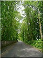
Dipple Road
Looking north up tree lined Dipple Road.
Image: © Mark Nightingale
Taken: 16 Jun 2011
0.07 miles
7
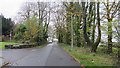
Dipple Road
Leaving Kilbirnie for an area of scattered livestock farms.
Image: © Richard Webb
Taken: 15 Oct 2011
0.08 miles
8
Redheugh Avenue, Kilbirnie, North Ayrshire
Housing development built around 2003 in the grounds of the Redheugh Estate.
These townhouses are situated near the site of the old walled garden.
Image: © Mark S
Taken: 10 Jun 2020
0.09 miles
9
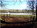
A Dusting of Snow
Just off Dipple Road, opposite Redheugh House, a light dusting of snow still remains in the field.
Image: © Mark S
Taken: 5 Feb 2015
0.09 miles
10
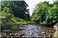
River Garnock, Kilbirnie, North Ayrshire
Near Lynn Drive.
Image: © Mark S
Taken: 25 Jul 2019
0.10 miles