IMAGES TAKEN NEAR TO
Milton Road, KILBIRNIE, KA25 7BB
Introduction
This page details the photographs taken nearby to Milton Road, KA25 7BB by members of the Geograph project.
The Geograph project started in 2005 with the aim of publishing, organising and preserving representative images for every square kilometre of Great Britain, Ireland and the Isle of Man.

There are currently over 7.5m images from over14,400 individuals and you can help contribute to the project by visiting https://www.geograph.org.uk
Image Map (Loading...)


Getting Data...Please wait
Leaflet Map data © OpenStreetMap
Images are licensed for reuse under creativecommons.org/licenses/by-sa/2.0
Notes
- Clicking on the map will re-center to the selected point.
- The higher the marker number, the further away the image location is from the centre of the postcode.
Image Listing (31 Images Found)
Images are licensed for reuse under creativecommons.org/licenses/by-sa/2.0
Image
Details
Distance
1
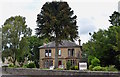
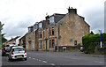
Avinhaugh, Kilbirnie, North Ayrshire
Situated on Milton Road, Avinhaugh was built between 1871 and 1881 for the Watt family who owned the nearby rope works.
There was a magnificent period greenhouse attached to the right of the building but sadly this no longer survives.
The Watt family owned the building until 1957 when it was sold.
For many years Avinhaugh has been occupied as four separate flats.
Image: © Mark S
Taken: 26 Jul 2019
0.01 miles
2
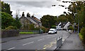
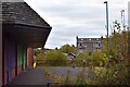
Milton Road, Kilbirnie, North Ayrshire
Looking down Milton Road from near Avinhaugh.
Image: © Mark S
Taken: 10 Oct 2020
0.04 miles
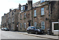
3
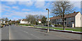
Milton Road
Milton Quadrant is on the right
Image: © Thomas Nugent
Taken: 13 Apr 2020
0.09 miles
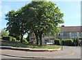
5
Milton Road, Kilbirnie, North Ayrshire
The tenement buildings on the right date from the early 20th century.
Milton Park is to the right.
Image: © Mark S
Taken: 4 Jul 2020
0.14 miles
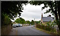
6
Milton Road
Older properties near the town centre.
Image: © Thomas Nugent
Taken: 13 Apr 2020
0.14 miles
7
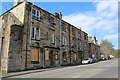
Milton Road
Boarded up windows in this older tenement at the start of the road.
Image: © Thomas Nugent
Taken: 13 Apr 2020
0.15 miles
8
Milton Road, Kilbirnie, North Ayrshire
Glenside villa to the right of the picture first appears on an 1895 map of the town.
Image: © Mark S
Taken: 9 Jun 2020
0.17 miles
9
Townhead, Kilbirnie, North Ayrshire
Former supermarket at Townhead.
The flats behind are located on Muirend Street.
https://www.geograph.org.uk/photo/6252369
Image: © Mark S
Taken: 17 Oct 2020
0.18 miles
10
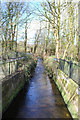
The Pundeavon Burn
The burn is channelised at this point just before it passes under Townhead.
Image: © Thomas Nugent
Taken: 13 Apr 2020
0.18 miles