IMAGES TAKEN NEAR TO
Townhead, KILBIRNIE, KA25 7AZ
Introduction
This page details the photographs taken nearby to Townhead, KA25 7AZ by members of the Geograph project.
The Geograph project started in 2005 with the aim of publishing, organising and preserving representative images for every square kilometre of Great Britain, Ireland and the Isle of Man.

There are currently over 7.5m images from over14,400 individuals and you can help contribute to the project by visiting https://www.geograph.org.uk
Image Map
Images are licensed for reuse under creativecommons.org/licenses/by-sa/2.0
Notes
- Clicking on the map will re-center to the selected point.
- The higher the marker number, the further away the image location is from the centre of the postcode.
Image Listing (126 Images Found)
Images are licensed for reuse under creativecommons.org/licenses/by-sa/2.0
Image
Details
Distance
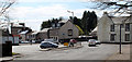
1
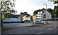
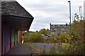
Townhead, Kilbirnie, North Ayrshire
Looking towards Bridge Street car park.
Image: © Mark S
Taken: 19 Sep 2020
0.01 miles
2
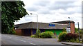
Townhead, Kilbirnie, North Ayrshire
Former supermarket at Townhead.
https://geograph.org.uk/photo/6252369
Image: © Mark S
Taken: 19 Sep 2020
0.02 miles
3
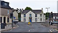
Bridge Street/School Wynd, Kilbirnie, North Ayrshire
2 School Wynd was home to James Houston Architects from at least 1939.
The building is still owned by the Houston family who now rent it out to several small businesses.
Image: © Mark S
Taken: 9 Jun 2020
0.02 miles
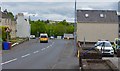
4
Townhead
Looking towards the town centre from the bridge over the Pundeavon Burn.
Image: © Thomas Nugent
Taken: 13 Apr 2020
0.03 miles
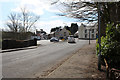
5
Townhead
A car park off Townhead in the centre of Kilbirnie.
Image: © Thomas Nugent
Taken: 13 Apr 2020
0.03 miles
6
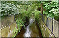
Pundeavon Burn, Kilbirnie, North Ayrshire
The Pundeavon Burn at Townhead, near where it meets the River Garnock.
Image: © Mark S
Taken: 26 Jul 2019
0.03 miles
7
School Wynd, Kilbirnie, North Ayrshire
Looking down School Wynd towards the mini roundabout. Townhead is to the left and Bridge Street is to the right.
Image: © Mark S
Taken: 9 Jun 2020
0.03 miles
8
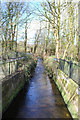
The Pundeavon Burn
The burn is channelised at this point just before it passes under Townhead.
Image: © Thomas Nugent
Taken: 13 Apr 2020
0.04 miles
9
Townhead, Kilbirnie, North Ayrshire
Former supermarket at Townhead.
The flats behind are located on Muirend Street.
https://www.geograph.org.uk/photo/6252369
Image: © Mark S
Taken: 17 Oct 2020
0.04 miles
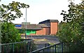
10
Townhead, Kilbirnie, North Ayrshire
Originally a Presto Supermarket, this building that now lies derelict was built sometime after 1966.
In 1994, the building was rebranded as Safeway, before being rebranded again in 2004, this time as Somerfield. The store closed some time around 2007 and apart from a brief period as a discount food store in 2017, it has been unoccupied since.
Image: © Mark S
Taken: 26 Jul 2019
0.05 miles