IMAGES TAKEN NEAR TO
Paduff Place, KILBIRNIE, KA25 7AR
Introduction
This page details the photographs taken nearby to Paduff Place, KA25 7AR by members of the Geograph project.
The Geograph project started in 2005 with the aim of publishing, organising and preserving representative images for every square kilometre of Great Britain, Ireland and the Isle of Man.

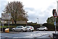
There are currently over 7.5m images from over14,400 individuals and you can help contribute to the project by visiting https://www.geograph.org.uk
Image Map
Images are licensed for reuse under creativecommons.org/licenses/by-sa/2.0
Notes
- Clicking on the map will re-center to the selected point.
- The higher the marker number, the further away the image location is from the centre of the postcode.
Image Listing (133 Images Found)
Images are licensed for reuse under creativecommons.org/licenses/by-sa/2.0
Image
Details
Distance
1
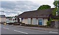
Kilbirnie Radio City
The former Radio City cinema is now a local community centre providing various facilities including keep fit equipment, a healthy eating cafe, and internet access.
Image: © Chris Court
Taken: 14 Aug 2005
0.01 miles
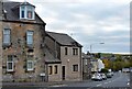
2
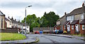
Paduff Place, Kilbirnie, North Ayrshire
Paduff Place is situated just off Glasgow Street in the shadow of St. Columba’s Church.
Image: © Mark S
Taken: 30 Jun 2020
0.01 miles
3
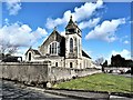
St. Columba's Parish Church - Kilbirnie
Church of Scotland, St. Columba's Parish Church, Kilbirnie.
Image: © Raibeart MacAoidh
Taken: 24 Mar 2018
0.03 miles
4
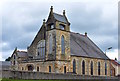
St. Columba?s, Kilbirnie, North Ayrshire
Known locally as the White Church, it was built in 1843 and was substantially redeveloped and enlarged in 1903. The Church became known as St. Columba’s from 1964.
Image: © Mark S
Taken: 23 Jul 2019
0.03 miles
5
Bank Street Car Park, Kilbirnie, North Ayrshire
Car park serving the Main Street.
Image: © Mark S
Taken: 10 Oct 2020
0.03 miles
7
Kilbirnie Police Station, North Ayrshire
Formerly the town’s registry office, Police Scotland eventually moved in after flooding badly damaged their station at Garnock Street.
Image: © Mark S
Taken: 26 Jul 2019
0.05 miles
8
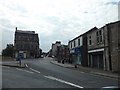
Main Street, Kilbirnie, North Ayrshire
The view along Main Street heading towards The Cross.
Image: © Mark S
Taken: 20 Jun 2020
0.05 miles
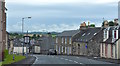
9
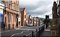
School Wynd, Kilbirnie, North Ayrshire
The tenement on the left appears on an 1856 map of the town.
Image: © Mark S
Taken: 17 Oct 2020
0.05 miles
10
Cochrane Street/School Wynd, Kilbirnie, North Ayrshire
Looking down Cochrane Street with Glasgow Street to the right and School Wynd beyond.
The A760 is still visible at the top of the picture, continuing on out of the town.
Image: © Mark S
Taken: 27 Jul 2019
0.05 miles