IMAGES TAKEN NEAR TO
KILBIRNIE, KA25 6LU
Introduction
This page details the photographs taken nearby to KA25 6LU by members of the Geograph project.
The Geograph project started in 2005 with the aim of publishing, organising and preserving representative images for every square kilometre of Great Britain, Ireland and the Isle of Man.

There are currently over 7.5m images from over14,400 individuals and you can help contribute to the project by visiting https://www.geograph.org.uk
Image Map
Images are licensed for reuse under creativecommons.org/licenses/by-sa/2.0
Notes
- Clicking on the map will re-center to the selected point.
- The higher the marker number, the further away the image location is from the centre of the postcode.
Image Listing (4 Images Found)
Images are licensed for reuse under creativecommons.org/licenses/by-sa/2.0
Image
Details
Distance
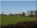
2
Track to Boagside Farm
The last use of this site was for a mink farm.
Image: © wfmillar
Taken: 19 Oct 2007
0.16 miles
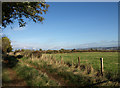
3
Pitcon Burn
View across burn towards Boag Farm.
Image: © wfmillar
Taken: 19 Oct 2007
0.18 miles
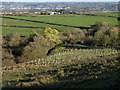
4
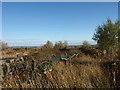
Boagside Farm
Abandoned mink farm. The many rows of cages can still be seen.
Image: © wfmillar
Taken: 19 Oct 2007
0.20 miles