IMAGES TAKEN NEAR TO
Glenriddet Avenue, KILBIRNIE, KA25 6LN
Introduction
This page details the photographs taken nearby to Glenriddet Avenue, KA25 6LN by members of the Geograph project.
The Geograph project started in 2005 with the aim of publishing, organising and preserving representative images for every square kilometre of Great Britain, Ireland and the Isle of Man.

There are currently over 7.5m images from over14,400 individuals and you can help contribute to the project by visiting https://www.geograph.org.uk
Image Map
Images are licensed for reuse under creativecommons.org/licenses/by-sa/2.0
Notes
- Clicking on the map will re-center to the selected point.
- The higher the marker number, the further away the image location is from the centre of the postcode.
Image Listing (51 Images Found)
Images are licensed for reuse under creativecommons.org/licenses/by-sa/2.0
Image
Details
Distance
1
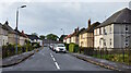
Munro Drive, Kilbirnie, North Ayrshire
Munro Drive as seen from Glenriddet Avenue.
Image: © Mark S
Taken: 12 Sep 2020
0.08 miles
2
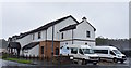
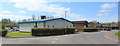
Garnock Valley Area Centre, Kilbirnie, North Ayrshire
Garnock Valley Area Centre is home to the health and social care department and the town’s housing office.
Image: © Mark S
Taken: 31 Aug 2019
0.09 miles
3
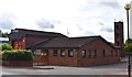
Kilbirnie Fire Station, North Ayrshire
Opened in December 1989.
Image: © Mark S
Taken: 23 Jul 2019
0.12 miles
4
Knoxville Road, Kilbirnie, North Ayrshire
This part of Knoxville Road leads to Westfield and several large properties. The Old Slaughterhouse was located further up the road. After it was demolished a house was built on the site in the late 1990s.
Image: © Mark S
Taken: 20 Jun 2020
0.12 miles
5
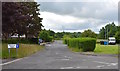
Paddockholm Road
Ambulance depot and fire station side by side.
Image: © Thomas Nugent
Taken: 13 Apr 2020
0.12 miles
6
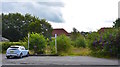
Site of Former Paterson?s Bus Depot, Kilbirnie, North Ayrshire
Paterson of Dalry acquired the site at Holmhead, Kilbirnie, in 1975 after it took over Garnock Valley Motors. The building was originally Dickie’s picture house.
Paterson’s ceased trading in February 2006 and the site has remained derelict ever since. The main building was destroyed by fire around 2008 and subsequently demolished. All that remains are a few lamps and an old diesel pump.
Image: © Mark S
Taken: 23 Jul 2019
0.12 miles
7
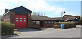
Kilbirnie fire station
On Paddockholm Road.
Image: © Thomas Nugent
Taken: 13 Apr 2020
0.12 miles
8
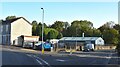
Holmhead, Kilbirnie, North Ayrshire
Looking towards Garnock Valley Ford’s compound and accident repair centre.
Image: © Mark S
Taken: 19 Sep 2020
0.13 miles
9
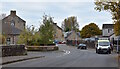
Holmhead, Kilbirnie, North Ayrshire
From Holmhead Bridge we are looking towards Holmhead.
Image: © Mark S
Taken: 17 Oct 2020
0.13 miles
10
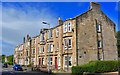
Holmhead, Kilbirnie, North Ayrshire
Prominent flats at the town’s Holmhead.
The War Memorial can be seen in the background.
Image: © Mark S
Taken: 23 Jul 2019
0.13 miles