IMAGES TAKEN NEAR TO
St. Brennans Court, KILBIRNIE, KA25 6LA
Introduction
This page details the photographs taken nearby to St. Brennans Court, KA25 6LA by members of the Geograph project.
The Geograph project started in 2005 with the aim of publishing, organising and preserving representative images for every square kilometre of Great Britain, Ireland and the Isle of Man.

There are currently over 7.5m images from over14,400 individuals and you can help contribute to the project by visiting https://www.geograph.org.uk
Image Map
Images are licensed for reuse under creativecommons.org/licenses/by-sa/2.0
Notes
- Clicking on the map will re-center to the selected point.
- The higher the marker number, the further away the image location is from the centre of the postcode.
Image Listing (9 Images Found)
Images are licensed for reuse under creativecommons.org/licenses/by-sa/2.0
Image
Details
Distance
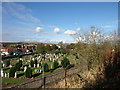
2
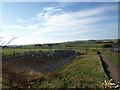
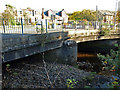
Kilbirnie Cemetery
View from the dismantled railway looking east over the new cemetery.
Image: © wfmillar
Taken: 19 Oct 2007
0.19 miles
3
Glengarnock
Taken from dismantled railway line.
Image: © wfmillar
Taken: 19 Oct 2007
0.22 miles
4
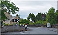
Kirkland Road, Glengarnock, North Ayrshire
Kirkland Road as seen from Grahamston Avenue.
Image: © Mark S
Taken: 31 Aug 2019
0.24 miles
5
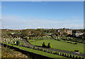
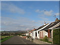
Kirkland Road, Glengarnock, North Ayrshire
Near the border between the village of Glengarnock and the town of Kilbirnie.
Image: © Mark S
Taken: 27 Jul 2019
0.25 miles
8
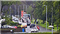
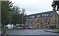
Dalry Road, Kilbirnie, North Ayrshire
Looking along Dalry Road towards the Thames filling station.
Image: © Mark S
Taken: 31 Aug 2019
0.25 miles
9
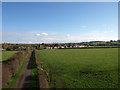
Kilbirnie Cemetery
View over the old cemetery north from dismantled railway track.
Image: © wfmillar
Taken: 19 Oct 2007
0.25 miles