IMAGES TAKEN NEAR TO
DALRY, KA24 5LB
Introduction
This page details the photographs taken nearby to KA24 5LB by members of the Geograph project.
The Geograph project started in 2005 with the aim of publishing, organising and preserving representative images for every square kilometre of Great Britain, Ireland and the Isle of Man.

There are currently over 7.5m images from over14,400 individuals and you can help contribute to the project by visiting https://www.geograph.org.uk
Image Map
Images are licensed for reuse under creativecommons.org/licenses/by-sa/2.0
Notes
- Clicking on the map will re-center to the selected point.
- The higher the marker number, the further away the image location is from the centre of the postcode.
Image Listing (27 Images Found)
Images are licensed for reuse under creativecommons.org/licenses/by-sa/2.0
Image
Details
Distance
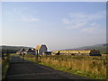
1
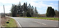
The A760 road
Approaching South Camphill farm.
Image: © Thomas Nugent
Taken: 13 Apr 2020
0.06 miles
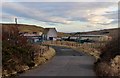
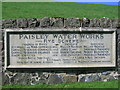
5
Water Works
Water works treating water from the Camphill and Muirhead reservoirs. An essential part of civilisation as we know it.
Image: © Chris Court
Taken: 4 Sep 2005
0.17 miles
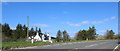
6
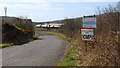
Camphill water treatment works
Off the A760 road between Kilbirnie and Largs.
Image: © Thomas Nugent
Taken: 13 Apr 2020
0.18 miles
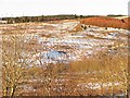
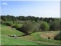
9
Camphill Reservoir
Rye Water is the name of the burn running from here to Dalry.
Image: © wfmillar
Taken: 27 Apr 2007
0.21 miles
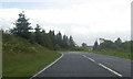
10
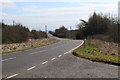
The A760 road
Looking towards Kilbirnie from Camphill water works.
Image: © Thomas Nugent
Taken: 13 Apr 2020
0.21 miles