IMAGES TAKEN NEAR TO
New Street, DALRY, KA24 5AE
Introduction
This page details the photographs taken nearby to New Street, KA24 5AE by members of the Geograph project.
The Geograph project started in 2005 with the aim of publishing, organising and preserving representative images for every square kilometre of Great Britain, Ireland and the Isle of Man.

There are currently over 7.5m images from over14,400 individuals and you can help contribute to the project by visiting https://www.geograph.org.uk
Image Map
Images are licensed for reuse under creativecommons.org/licenses/by-sa/2.0
Notes
- Clicking on the map will re-center to the selected point.
- The higher the marker number, the further away the image location is from the centre of the postcode.
Image Listing (75 Images Found)
Images are licensed for reuse under creativecommons.org/licenses/by-sa/2.0
Image
Details
Distance
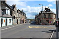
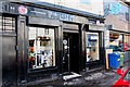
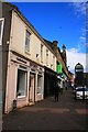
1

New Street, Dalry
The low building behind the road sign (now converted for residential use) was formerly the Museum Tavern.
Image: © Leslie Barrie
Taken: 16 May 2014
0.01 miles
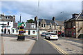
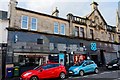
3
Dalry centre from A737
Main junction in centre of town showing church
Image: © John Firth
Taken: 27 Jul 2012
0.02 miles
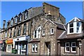
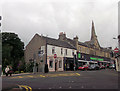
10
Irvine's Bakery Dalry
One of the best bakeries in the local area
Image: © Ian Rainey
Taken: 6 May 2017
0.03 miles