IMAGES TAKEN NEAR TO
DALRY, KA24 4LQ
Introduction
This page details the photographs taken nearby to KA24 4LQ by members of the Geograph project.
The Geograph project started in 2005 with the aim of publishing, organising and preserving representative images for every square kilometre of Great Britain, Ireland and the Isle of Man.

There are currently over 7.5m images from over14,400 individuals and you can help contribute to the project by visiting https://www.geograph.org.uk
Image Map
Images are licensed for reuse under creativecommons.org/licenses/by-sa/2.0
Notes
- Clicking on the map will re-center to the selected point.
- The higher the marker number, the further away the image location is from the centre of the postcode.
Image Listing (7 Images Found)
Images are licensed for reuse under creativecommons.org/licenses/by-sa/2.0
Image
Details
Distance
1
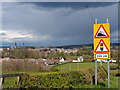
B714 Road Signs, Dalry
View from the Saltcoats road.
Image: © wfmillar
Taken: 24 Apr 2012
0.15 miles
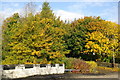
2
Dark skies Dalry
View from the Saltcoats Road.
Image: © wfmillar
Taken: 23 Apr 2012
0.15 miles
4

Waterfall on the Caaf water
Nice waterfall near Dalry, North Ayrshire.
Image: © Iain Crockatt
Taken: 22 Aug 2010
0.19 miles
5
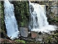
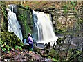
Lynn Spout - Dalry
Lynn Spout on the Caaf Water in Lynn Glen, Dalry.
Image: © Raibeart MacAoidh
Taken: 4 Nov 2018
0.20 miles
6
Lynn Spout - Dalry
Lynn Spout on the Caaf Water in Lynn Glen, Dalry.
Image: © Raibeart MacAoidh
Taken: 12 Nov 2020
0.20 miles
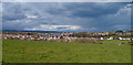
7
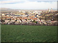
Dalry
Taken from near Craighead on the Saltcoats road.
Image: © wfmillar
Taken: 24 Jan 2007
0.25 miles