IMAGES TAKEN NEAR TO
DALRY, KA24 4LH
Introduction
This page details the photographs taken nearby to KA24 4LH by members of the Geograph project.
The Geograph project started in 2005 with the aim of publishing, organising and preserving representative images for every square kilometre of Great Britain, Ireland and the Isle of Man.

There are currently over 7.5m images from over14,400 individuals and you can help contribute to the project by visiting https://www.geograph.org.uk
Image Map (Loading...)


Getting Data...Please wait
Leaflet Map data © OpenStreetMap
Images are licensed for reuse under creativecommons.org/licenses/by-sa/2.0
Notes
- Clicking on the map will re-center to the selected point.
- The higher the marker number, the further away the image location is from the centre of the postcode.
Image Listing (6 Images Found)
Images are licensed for reuse under creativecommons.org/licenses/by-sa/2.0
Image
Details
Distance
1
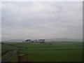
Patchwork
Patchwork of fields surrounding Bankhead farm. Just getting into the picture on the left are spoil heaps from the gravel pit workings.
Image: © Chris Court
Taken: 8 Dec 2005
0.01 miles
2
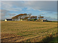
Bankhead
View across farmland to Bankhead farm.
Image: © Chris Court
Taken: 8 Dec 2005
0.07 miles
3
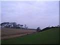
Barley Field
Water logged fields means the entire crop cannot be harvested.
Image: © wfmillar
Taken: 3 Oct 2008
0.09 miles
4
Bankhead Farm
Looking over harvested barley field.
Image: © wfmillar
Taken: 28 Oct 2008
0.10 miles
5
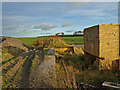
Weighbridge site
Former weighbridge site at an abandoned gravel pit.
Image: © wfmillar
Taken: 28 Oct 2008
0.21 miles
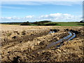
6
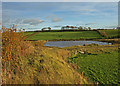
Flooded Gravel Pit
These workings are now abandoned. This shot was taken from the former site of the weighbridge.
Image: © wfmillar
Taken: 28 Oct 2008
0.23 miles