IMAGES TAKEN NEAR TO
Kilwinning Road, DALRY, KA24 4LA
Introduction
This page details the photographs taken nearby to Kilwinning Road, KA24 4LA by members of the Geograph project.
The Geograph project started in 2005 with the aim of publishing, organising and preserving representative images for every square kilometre of Great Britain, Ireland and the Isle of Man.

There are currently over 7.5m images from over14,400 individuals and you can help contribute to the project by visiting https://www.geograph.org.uk
Image Map
Images are licensed for reuse under creativecommons.org/licenses/by-sa/2.0
Notes
- Clicking on the map will re-center to the selected point.
- The higher the marker number, the further away the image location is from the centre of the postcode.
Image Listing (11 Images Found)
Images are licensed for reuse under creativecommons.org/licenses/by-sa/2.0
Image
Details
Distance
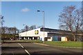
5
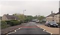
Townend Street at Lynn Avenue
Lidl supermarket visible ahead
Image: © John Firth
Taken: 19 May 2013
0.11 miles
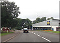
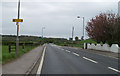
6
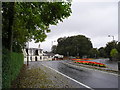
Colourful Junction
Road junction, looking north on the A737 with the minor road to Saltcoats on the left. The colourful bedding scheme comprises red and yellow begonias, brightening up a wet day in October.
Image: © Chris Court
Taken: 9 Oct 2005
0.14 miles
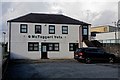
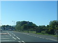
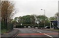
10
Dalry to Kilwinning Road
A737 leading to Kilwinning.
Image: © Gordon Dowie
Taken: 2 May 2010
0.20 miles